![[Home]](images/nav_home.gif) |
 |
 |
 |
 |
 |
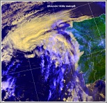
| metopB ch2+4 Arctic Ocean to the Grain Coast agf05-1038-a-apt.JPG 1,112 KB |
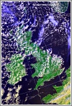
ch1+2+4 Convection over the UK, deepest in north, mainly capped in south agf05-1038-b-uk.JPG 675 KB |
ch1+2+4 Frontal cloud band over northern France agf05-1038-c-fr.JPG 460 KB |
ch1+2+4 Weak vortex near northwest Iberia and associated cloud agf05-1038-d-ib.JPG 439 KB |
ch1+2+4 Frontal cloud band over Germany and the Baltic agf05-1038-e-dk.JPG 419 KB |
 |
 |
 |
 |
 |
| ch1+2+4 Frontal low over southern Scandinavia and associated cloud agf05-1038-f-sca.JPG 438 KB |
ch1+2+4 Low east of Iceland and orographic waves agf05-1038-g-ic.JPG 447 KB |
ch1+2+4 Low near Jan Mayen and associated cloud agf05-1038-h-nos.JPG 372 KB |
ch1+2+4 Frontal cloud band over southern Svalbard and ice/snow disposition agf05-1038-i-sv.JPG 391 KB |
ch-th Colour coded thermal image (0 to -60C) Arctic to Iberia agf05-1038-j-apt.JPG 1,217 KB |
 |
 |
|||
| ch-vg Vegetation index Arctic to the Grain Coast agf05-1038-k-apt.JPG 1,055 KB |
ch2+4 Enlarged visible/IR composite image of southern UK agf05-1038-l-uk-s.JPG 843 KB |