![[Home]](images/nav_home.gif) |
 |
 |
 |
 |
 |
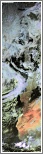
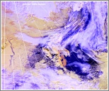
| metopC ch2+4 Arctic Ocean to the Grain Coast agf13-1026-a-apt.JPG 1,164 KB |
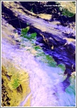
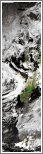
ch1+2+4 Frontal cloud band over western UK and Ireland agf13-1026-b-uk.JPG 444 KB |
ch1+2+4 Convection developing over northeast France and frontal cirrus agf13-1026-c-fr.JPG 447 KB |
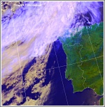
ch1+2+4 Frontal cloud band northwest of Iberia agf13-1026-d-ib.JPG 355 KB |
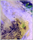
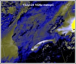
ch1+2+4 Convection over Germany and Denmark agf13-1026-e-ge.JPG 651 KB |
 |
 |
 |
 |
 |
| ch1+2+4 Shallow low over western Ireland and associated cloud agf13-1026-f-ir.JPG 441 KB |
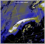
ch1+2+4 Widespread convection over Scandinavia, some deep agf13-1026-g-sca.JPG 696 KB |
ch1+2+4 Low northeast of Svalbard and ice/snow disposition agf13-1026-h-sv.JPG 525 KB |
ch-th Colour coded thermal image (0 to -60C) Arctic to Iberia agf13-1026-i-apt.JPG 1,314 KB |
ch-vg Vegetation index Arctic to the Grain Coast agf13-1026-j-apt.JPG 1,085 KB |
 |
 |
 |
||
| ch4-5 Dust storm over Mauritania with orographic waves agf13-1026-k-mu.JPG 389 KB |
ch4+5 Areas of raised dust over the Sahara, thick in east agf13-1026-l-apt-s.JPG 225 KB |
ch4+5 Enlarged visible/IR composite image of southern UK agf13-1026-m-uk-s.JPG 793 KB |