![[Home]](images/nav_home.gif) |
 |
 |
 |
 |
 |
| metopC ch2+4 Arctic Ocean to the Grain Coast agi22-1038-a-apt.JPG 1,066 KB |
ch1+2+4 Areas of deep convection over southern UK and low stratiform cloud to north agi22-1038-b-uk.JPG 444 KB |
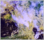
ch1+2+4 Deep convection over France agi22-1038-c-fr.JPG 462 KB |
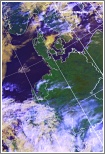
ch1+2+4 Mainly limited convection developing over Iberia agi22-1038-d-ib.JPG 526 KB |
ch1+2+4 Cirrus in places over Germany agi22-1038-e-ge.JPG 406 KB |
 |
 |
 |
 |
 |
| ch1+2+4 Convective vortex west of Biscay agi22-1038-f-fr-w.JPG 430 KB |
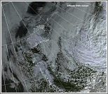
ch1+2+4 Frontal cloud band over southern Scandinavia agi22-1038-g-sca.JPG 608 KB |
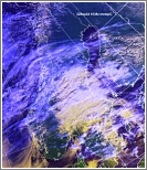
ch1+2+4 Frontal cloud band with vortex southeast of Jan Mayen agi22-1038-h-ic.JPG 549 KB |
ch2+4 Frontal cloud southeast of Svalbard and ice disposition agi22-1038-i-sv.JPG 506 KB |
ch-th Colour coded thermal image (0 to -60C) Arctic to Iberia agi22-1038-j-apt.JPG 1,325 KB |
 |
 |
|||
| ch-vg Vegetation index Arctic to the Grain Coast agi22-1038-k-apt.JPG 999 KB |
ch2+4 Enlarged visible/IR composite image of southern UK agi22-1038-l-uk-s.JPG 948 KB |