![[Home]](images/nav_home.gif) |
 |
 |
 |
 |
 |
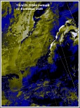
| metopB ch2+4 Arctic Ocean to the Grain Coast ahg13-1004-a-apt.JPG 1,166 KB |
ch1+2+4 Frontal cloud layers east and southwest of the UK ahg13-1004-b-uk.JPG 393 KB |
ch1+2+4 Scattered convection developing over southern France ahg13-1004-c-fr.JPG 478 KB |
ch1+2+4 Frontal cloud band over northwest Iberia ahg13-1004-d-ib.JPG 438 KB |
ch1+2+4 Low over northeast Germany and associated cloud and deep convection ahg13-1004-e-ge.JPG 613 KB |
 |
 |
 |
 |
 |
| ch1+2+4 Deep convection in frontal band over southern Scandinavia ahg13-1004-f-sca.JPG 442 KB |
ch1+2+4 Deepening low over the Barents Sea and associated cloud ahg13-1004-g-bas.JPG 526 KB |
ch1+2+4 Low stratiform cloud over western Svalbard and ice/snow disposition ahg13-1004-h-sv.JPG 499 KB |
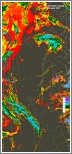
ch-th Colour coded thermal image (0 to -60C) Arctic to Iberia ahg13-1004-i-apt.JPG 995 KB |
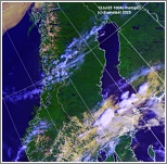
ch-vg Vegetation index Arctic to the Grain Coast ahg13-1004-j-apt.JPG 1,088 KB |
 |
 |
|||
| ch4-5 500mi long dust storm over Algeria and Mauritania ahg13-1004-k-apt-s.JPG 344 KB |
ch2+4 Enlarged visible/IR composite image of southern UK ahg13-1004-l-uk-s.JPG 1,196 KB |