![[Home]](images/nav_home.gif) |
 |
 |
 |
 |
 |
| metopC ch2+4 Arctic Ocean to the Grain Coast ahh12-1034-a-apt.JPG 1,208 KB |
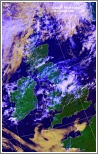
ch1+2+4 Medium level convection over central UK and frontal cloud in north ahh12-1034-b-uk.JPG 490 KB |
ch1+2+4 Fog/low stratiform cloud over Biscay ahh12-1034-c-fr-w.JPG 367 KB |
ch1+2+4 High level convection over western Iberia ahh12-1034-d-ib.JPG 400 KB |
ch1+2+4 Low southwest of Ireland and associated cloud ahh12-1034-e-ir-s.JPG 424 KB |
 |
 |
 |
 |
 |
| ch1+2+4 Frontal cloud over Denmark ahh12-1034-f-dk.JPG 514 KB |
ch1+2+4 Frontal cloud over northern Scandinavia and convection to south, deep in east ahh12-1034-g-sca.JPG 640 KB |
ch1+2+4 Frontal coud band over Faeroe ahh12-1034-h-fa.JPG 456 KB |
ch1+2+4 Shallow low near Jan Mayen and associated cloud ahh12-1034-i-nos.JPG 401 KB |
ch1+2+4 Frontal cloud south and west of Svalbard and ice/snow disposition ahh12-1034-i-sv.JPG 487 KB |
 |
 |
 |
 |
 |
| ch1+2+4 Atmospheric gravity wave train north of Cape Verde Is. ahh12-1034-k-cv.JPG 265 KB |
ch-th Colour coded thermal image (0 to -60C) Arctic to Iberia ahh12-1034-l-apt.JPG 1,058 KB |
ch-vg Vegetation index Arctic to the Grain Coast ahh12-1034-m-apt.JPG 1,110 KB |
ch4-5 Area of raised dust over the Sahara ahh12-1034-n-apt-s.JPG 165 KB |
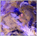
ch2+4 Enlarged visible/IR composite image of southern UK ahh12-1034-o-uk-s.JPG 997 KB |